


Honduras Driving Advice and Car Hire Info
Driving In Honduras
Honduras drives on the right and you can drive using the photo licence of most countries for up to 3 months.
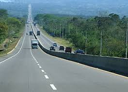
Honduras has a reasonably well maintained highway network. main routes include-
The CA-1 which is the section of the Pan American highway running through the country starting at the El Salvador border at El Amatillo and runs through Nacaome, Jícaro Galán , until it meets the Carretera del Sur (CA-5) – then heads to the Nicaraguan frontier at El Espino.
CA-5- Carretera del Norte – Between Tegucigalpa and San Pedro Sula and Carretera del Sur from the capital to San Lorenzo in Valle department.
CA-13 -San Pedro Sula to La Ceiba and other towns on the Atlantic coast. It also links Puerto Cortés with Omoa, Cuyamel and Corinto at the Guatemalan border.
Carretera La Ceiba-Trujillo from La Ceiba to Trujillo, finishing at Puerto Castilla.
Carretera a Olancho – This highway links Tegucigalpa with Olancho
CA-6 -Carretera de Oriente CA-6 The Eastern Highway runs from Tegucigalpa to the Nicaraguan border.
CA-4 – Carretera de Occidente – The Western Highway runs from San Pedro Sula through the western part of the country to the Guatemalan border.
Smaller roads are likely to be less well maintained and will generally be unlit, and in parts of the country can be steep and winding. Roads between the main tourist locations in Honduras are generally of an acceptable standard. In more isolated locations, roads are unpaved and four-wheel drive vehicles are advisable. Some of the most dangerous stretches for road travel include: Tegucigalpa to Choluteca, because of dangerous mountain curves; El Progreso to La Ceiba, because of animal crossings and the poor condition of bridges from flooding. The best route to the north coast from the south is CA-5 to route 21 to CA-13 via Tela to La Ceiba and Trujillo
Driving standards in Honduras are often poor. In Towns, most junctions seem to operate on the informal ‘who arrives first/eye contact’ right of way system. I found that drivers often tend to pull into traffic from side roads causing cars on the main carriageway to brake.
Crime is a concern.There have been attacks on vehicles on the roads from Limones to La Union and also from Olancho via Salama to Saba. Exercise particular caution on the roads from Gualaco to San Estaban and La Esparanza to Gracias. The isolated roads of the Department of Santa Barbara have also seen criminal activity, and hijackings of vehicles have occurred on roads in/around Tela, La Ceiba, Trujillo and El Progreso. Take great care on the highway between San Pedro Sula and Tela especially near the palm tree plantations near El Progreso where attacks have been reported. You should always avoid driving at night as the roads and vehicles are poorly lit and wandering livestock in rural areas can present an additional hazard. In Cities drive with the windows up and doors locked at all times.
Driving on the Bay Islands is easier and more laid back than on the mainland . Utila is quiet with only one main road on the Island. Roatan is also a small Island, around 40 miles long by a couple of miles wide. There are a number of car rental options on the Island including Avis, Thrifty and Econo rent.
Renting a car for a day would certainly enable you to see the majority of the Island, though another good option, and one more usually taken by tourists is to rent a scooter or motorbike. The most established rental company on the Island is Captain Van’s, which has outlets in West Bay and West End.
The roads are generally in good condition, with the odd pot hole here and there, particularly in The South East of the Island between Flowers Bay and the turn off to West Bay. The main hazard is taxi drivers, stopping unexpectedly in front of you. Generally when on the road, cars give you enough room though there can be a lot of traffic between Dixon Cove ,Coxen Hole and the Southern Beaches when there are Cruise Ships visiting the Island (most days!). The Island only has one main road running North South and with a loop connecting Coxen Hole, Sandy Bay and West End- its impossible to get lost.
Once past Los Fuertes heading North, the roads are really quiet and riding is a pleasure, as you pass through hilly, green countryside bordered by the sparkling waters of the Caribbean. The paved road continues up to Oak Ridge in the North where you can take a boat ride to see the mangroves and stilt houses.If you want to get off the paved road, a reasonable dirt track leads up the West Coast through the villages of Mud Hole, Corozal and Hottest Sparrow, before emerging near the mall North of Los Fuertes – if you plan to do this route on a scooter, check with Captain Vans before setting off on the condition of the road.
Although I try and keep the information in the site updated as much as possible, in a rapidly moving world, situations can change daily. Therefore please use the site as an approximate guide, and in conjunction with other resources in order to form your view on driving conditions, roads, safety etc.
Honduras Car Rental –
Hertz, Alamo, National, Avis, Thrifty, have branches here. Also usually features on the main broker sites and Web discount sites such as LastMinute.com
We currently have no local car rental partners in Honduras. If you are a local car rental company who would like to feature on DriverAbroad.com please check details on our Partnering page or contact us on ADriverAbroad@Outlook.com
Honduras Self Driving Rules-
When I checked only National allow cars to be driven outside Honduras for an additional fee.
2 comments